
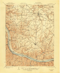
1931 Map of Felicity
USGS Topo · Published 1931About this map
The Ohio River forms the winding southern boundary of this 1931 study, serving as a vital corridor for riverside settlements like Chilo, Neville, Moscow, and Point Pleasant. The interior of Franklin and Tate townships is densely dotted with early twentieth-century rural infrastructure, particularly a high concentration of schools such as Maple Bell School, Mt Hygiene School, and Republican School. The Cincinnati Georgetown and Portsmouth RR cuts through the northern section, connecting the hub of Bethel to the surrounding agricultural landscape.
Find a feature on this map
133 named features on this map. Tap any name to fly to it.
Don’t see what you’re looking for? This feature index may not catch every label — zoom into the map to look around manually.
Map Details
Editions of this 1931 Felicity Map
2 editions found
Other maps of this area

1898 · East Cincinnati
USGS Topo · 1:62,500

1914 · East Cincinnati
USGS Topo · 1:62,500

1914 · Batavia
USGS Topo · 1:48,000

1915 · Maysville
USGS Topo · 1:62,500

1916 · Batavia
USGS Topo · 1:62,500

1917 · Sardinia
USGS Topo · 1:62,500

1919 · Maysville
USGS Topo · 1:62,500

1928 · Higginsport
USGS Topo · 1:48,000

1929 · Alexandria
USGS Topo · 1:48,000

1930 · Falmouth
USGS Topo · 1:48,000