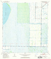
1953 Map of Fellsmere 4 NW
USGS Topo · Published 1970About this map
Blue Cypress Lake and the expansive St Johns Marsh dominate this landscape, reflecting the hydrological complexity of Indian River County during the early 1950s. The map illustrates a transitional period in Florida's interior, where agricultural engineering began to reshape the wetlands. An intricate network of Levee systems and a Spoil Bank reveal the extensive efforts to manage water for industrial and agricultural use. A focal point of this activity is the Sugar Processing Plant located near the Florida Central and Trans-Florida railroad line, highlighting the region's reliance on rail transport for its sugar economy. Scattered throughout the eastern sections are several Flowing Wells, indicating the subterranean water resources that supported local operations, while a Gaging Sta monitors the slow-moving flow of the marshlands.
Find a feature on this map
9 named features on this map. Tap any name to fly to it.
Don’t see what you’re looking for? This feature index may not catch every label — zoom into the map to look around manually.
Map Details
Editions of this 1953 Fellsmere 4 NW Map
3 editions found
Other maps of this area

1949 · Fellsmere
USGS Topo · 1:24,000

1951 · Fellsmere
USGS Topo · 1:24,000

1953 · Fellsmere SW
USGS Topo · 1:24,000

1953 · Fort Drum
USGS Topo · 1:24,000

1953 · Fellsmere 4 SE
USGS Topo · 1:24,000

1953 · Fort Drum NE
USGS Topo · 1:24,000

1953 · Fellsmere 4 SW
USGS Topo · 1:24,000

1953 · Kenansville SE
USGS Topo · 1:24,000

1953 · Fellsmere 4 NW
USGS Topo · 1:24,000
1953 · Fellsmere 4 NE
USGS Topo · 1:24,000