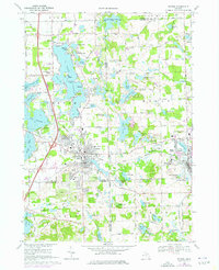
1969 Map of Fenton
USGS Topo · Published 1976About this map
Lake Fenton dominates the northern landscape of this Genesee County survey, its irregular shoreline dotted with local landmarks like Case Island, Log Cabin Point, and the Lakeside community. The map illustrates a period of significant residential expansion and recreational development around the glacial lake basins, including Lake Ponemah and Silver Lake. The urban center of Fenton is shown in detail, where the Shiawassee River winds through the heart of town near Bush Park and the Eastern School. To the east, the village of Holly serves as a secondary hub, defined by the crossing of the Shiawassee River and the Chesapeake and Ohio railroad corridor. The area's social and educational fabric is well-documented through features such as the Adelphian Academy, multiple historic burial grounds like Oakwood Cemetery, and even mid-century cultural staples like the Drive-in Theater along the southwestern shorelines.
Find a feature on this map
98 named features on this map. Tap any name to fly to it.
Don’t see what you’re looking for? This feature index may not catch every label — zoom into the map to look around manually.
Map Details
Editions of this 1969 Fenton Map
Other maps of this area

1907 · Howell
USGS Topo · 1:62,500

1909 · Howell
USGS Topo · 1:62,500

1909 · Milford
USGS Topo · 1:62,500

1920 · Holly
USGS Topo · 1:62,500

1922 · Holly
USGS Topo · 1:62,500

1922 · Durand
USGS Topo · 1:62,500

1936 · Highland
USGS Topo · 1:31,680

1942 · Highland
USGS Topo · 1:24,000

1943 · Holly
USGS Topo · 1:62,500

1943 · Durand
USGS Topo · 1:62,500