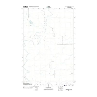
2011 Map of Fish Creek Lake
USGS Topo · Published 2011About this map
Heart River meanders through this section of Morton County, North Dakota, defining much of the drainage pattern as it cuts through the prairie. The landscape is marked by the presence of Fish Creek Lake, an impoundment created by the Fish Creek Dam along its namesake Fish Creek. This water feature stands as a significant point of interest in an area otherwise dominated by a sparse network of section-line roads, such as 37th Ave and 49th St. Near the southern edge of the survey, Dawson Dam and the Little Heart River further emphasize the importance of water management in this agricultural region. The map provides a clear view of the rural infrastructure at the start of the decade, showing how the land is divided and accessed by local residents and ranchers.
Find a feature on this map
18 named features on this map. Tap any name to fly to it.
Don’t see what you’re looking for? This feature index may not catch every label — zoom into the map to look around manually.
Map Details
Editions of this 2011 Fish Creek Lake Map
This is the sole edition of this map. No revisions or reprints were ever made.
Other maps of this area

1954 · Bismarck
USGS Topo · 1:250,000

1958 · Bismarck
USGS Topo · 1:250,000

1970 · Judson
USGS Topo · 1:24,000

1972 · Sweet Briar
USGS Topo · 1:24,000

1972 · Crown Butte Lake
USGS Topo · 1:24,000

1980 · Green Ridge
USGS Topo · 1:24,000

1980 · Otter Creek East
USGS Topo · 1:24,000

1980 · Fallon NE
USGS Topo · 1:24,000
1980 · Fish Creek Lake
USGS Topo · 1:24,000

1980 · Nygren Dam
USGS Topo · 1:24,000