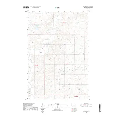
2020 Map of Fish Creek Lake
USGS Topo · Published 2020About this map
The Heart River winds through the central plains of Morton County, carving a distinct path through the rolling topography of this North Dakota landscape. At the northern edge, Fish Creek Lake and its feeder stream, Fish Cr, provide a primary water source and topographical focus for the surrounding area. The terrain is marked by significant landmarks such as Chimney Butte and the elongated Oak Coulee Ridge, which rise above the river valleys. A network of rural section-line roads, including Co Rd 137 and 34th Ave, crisscrosses the landscape, reflecting the established Public Land Survey System. Along the river's bend, features like Goose Bar indicate the shifting alluvial patterns of the waterway, while the Little Heart River and Chanta Peta Cr drain the southeastern portion of the quadrangle.
Find a feature on this map
27 named features on this map. Tap any name to fly to it.
Don’t see what you’re looking for? This feature index may not catch every label — zoom into the map to look around manually.
Map Details
Editions of this 2020 Fish Creek Lake Map
This is the sole edition of this map. No revisions or reprints were ever made.
Other maps of this area

1954 · Bismarck
USGS Topo · 1:250,000

1958 · Bismarck
USGS Topo · 1:250,000

1970 · Judson
USGS Topo · 1:24,000

1972 · Sweet Briar
USGS Topo · 1:24,000

1972 · Crown Butte Lake
USGS Topo · 1:24,000

1980 · Green Ridge
USGS Topo · 1:24,000

1980 · Otter Creek East
USGS Topo · 1:24,000

1980 · Fallon NE
USGS Topo · 1:24,000
1980 · Fish Creek Lake
USGS Topo · 1:24,000

1980 · Nygren Dam
USGS Topo · 1:24,000