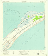
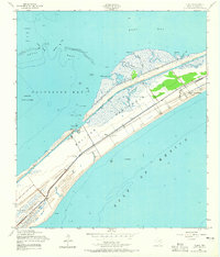
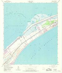
1954 Map of Flake
USGS Topo · Published 1958This historical map portrays the area of Flake in 1954, primarily covering Galveston. Featuring a scale of 1:24000, this map provides a highly detailed snapshot of the terrain, roads, buildings, counties, and historical landmarks in the Flake region at the time. Published in 1958, it is one of 4 known editions of this map due to revisions or reprints.
Find a feature on this map
20 named features on this map. Tap any name to fly to it.
Don’t see what you’re looking for? This feature index may not catch every label — zoom into the map to look around manually.
Map Details
Editions of this 1954 Flake Map
4 editions found
Historical Maps of Elmgrove Through Time
39 maps found

1929 Algoa
Galveston County, TX

1929 Karankawa Lake
Galveston County, TX

1929 Virginia Point
Galveston County, TX

1931 Flake
Galveston County, TX

1931 Lake Como
Galveston County, TX

1932 Algoa
Galveston County, TX

1932 Bolivar Point
Galveston County, TX

1932 Virginia Point
Galveston County, TX

1933 Bolivar Point
Galveston County, TX

1933 Caplen
Galveston County, TX

1933 Carancahua Lake
Galveston County, TX

1933 Flake
Galveston County, TX

1933 Lake Como
Galveston County, TX

1933 San Luis Pass
Galveston County, TX

1933 The Jetties
Galveston County, TX

1943 Caplen
Galveston County, TX

1943 Carancahua Lake
Galveston County, TX

1943 Flake
Galveston County, TX

1943 Lake Como
Galveston County, TX

1943 Port Bolivar
Galveston County, TX

1943 San Luis Pass
Galveston County, TX

1943 The Jetties
Galveston County, TX

1943 Virginia Point
Galveston County, TX

1954 Caplen
Galveston County, TX

1954 Flake
Galveston County, TX

1954 Lake Como
Galveston County, TX

1954 Port Bolivar
Galveston County, TX

1954 The Jetties
Galveston County, TX

1954 Virginia Point
Galveston County, TX

1956 Algoa
Galveston County, TX

1963 San Luis Pass
Galveston County, TX

1963 Sea Isle
Galveston County, TX

1994 Caplen
Galveston County, TX

1994 Flake
Galveston County, TX

1994 Lake Como
Galveston County, TX

1994 Port Bolivar
Galveston County, TX

1994 The Jetties
Galveston County, TX

1994 Virginia Point
Galveston County, TX

1995 Virginia Point
Galveston County, TX