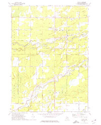
1973 Map of Floyd
USGS Topo · Published 1976About this map
The Chippewa River and Pine River carve through this landscape of the mid-1970s, defining a region where industrial activity meets protected woodlands. In the northwest, an expansive Oil Field and numerous Brine Wells indicate the heavy subsurface extraction prevalent in Midland County, while the central portions are dominated by the Tittabawassee State Forest. Small settlements like Floyd and St Elmo appear along a grid of section roads, many named for local families or distance, such as 8 Mile Road and 10 Mile Road. Local spiritual and community life is anchored by the Midland Missionary Church and the Midland Church, with a centrally located Township Cemetery serving the rural population. The presence of several Gravel Pits and a Sandpit near Sucker Creek further highlights the utilitarian relationship between the local economy and the river valley's natural resources.
Find a feature on this map
98 named features on this map. Tap any name to fly to it.
Don’t see what you’re looking for? This feature index may not catch every label — zoom into the map to look around manually.
Map Details
Editions of this 1973 Floyd Map
This is the sole edition of this map. No revisions or reprints were ever made.
Other maps of this area

1930 · Shepherd
USGS Topo · 1:48,000

1934 · Sanford
USGS Topo · 1:62,500

1934 · Merrill
USGS Topo · 1:62,500

1935 · Alma
USGS Topo · 1:62,500

1936 · Shepherd
USGS Topo · 1:62,500

1936 · Sanford
USGS Topo · 1:62,500

1937 · Merrill
USGS Topo · 1:62,500

1938 · Alma
USGS Topo · 1:62,500

1954 · Midland
USGS Topo · 1:250,000

1958 · Midland
USGS Topo · 1:250,000
Featured Places
- Porter, Porter Township
- Greendale Township, MI
- Porter Township, MI
- Saint Elmo, Lee Township
- Floyd, Lee Township