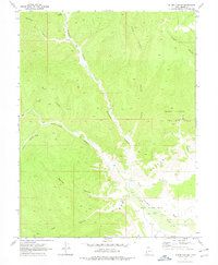
1970 Map of Flume Canyon
USGS Topo · Published 1978About this map
The Book Cliffs dominate this eastern Utah landscape, where deeply etched drainages like Diamond Canyon and Flume Canyon reveal a geography defined by its natural resources. In the early 1970s, industrial activity centered on the Cisco Springs North Gas Field and a broader Oil and Gas Field to the east. These energy extraction sites are marked by numerous Drill Holes, while a solitary Mine is noted in the central breaks. Human presence is otherwise sparse and functional, indicated by a Corral and a network of Jeep Trails that navigate the terrain between Oak Springs and Cottonwood Wash. The map records a specific moment in Grand County's transition from traditional ranching landmarks to a modern energy landscape during the peak of regional petroleum exploration.
Find a feature on this map
19 named features on this map. Tap any name to fly to it.
Don’t see what you’re looking for? This feature index may not catch every label — zoom into the map to look around manually.
Map Details
Editions of this 1970 Flume Canyon Map
3 editions found
Other maps of this area

1885 · East Tavaputs
USGS Topo · 1:250,000

1956 · Grand Junction
USGS Topo · 1:250,000

1959 · Grand Junction
USGS Topo · 1:250,000

1960 · Grand Junction
USGS Topo · 1:250,000

1962 · Grand Junction
USGS Topo · 1:250,000

1963 · Tenmile Canyon
USGS Topo · 1:62,500

1963 · Sego Canyon
USGS Topo · 1:62,500

1964 · Grand Junction
USGS Topo · 1:250,000

1965 · Grand Junction
USGS Topo · 1:250,000

1970 · Flume Canyon
USGS Topo · 1:24,000