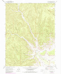
1970 Map of Flume Canyon
USGS Topo · Published 1987About this map
The dramatic southern escarpment of the Book Cliffs dominates this survey, revealing a landscape defined by deep erosional drainages and 20th-century energy exploration. Following aerial photography in 1969, the terrain showcases a complex network of canyons, including Diamond Canyon, Cottonwood Canyon, and Coal Canyon, which cut through the high plateau. The industrial footprint of the era is evident in the southeastern reaches, where the Cisco Springs North Gas Field and a broader Oil and Gas Field are marked by numerous Drill Holes. Resource extraction and land use are further highlighted by scattered Mines and a Corral, while transportation is limited to rugged Jeep Trails that navigate the topographic breaks. This map captures Grand County at a time when the high desert was being actively probed for its subterranean wealth amidst its traditional ranching and mining roots.
Find a feature on this map
20 named features on this map. Tap any name to fly to it.
Don’t see what you’re looking for? This feature index may not catch every label — zoom into the map to look around manually.
Map Details
Editions of this 1970 Flume Canyon Map
3 editions found
Other maps of this area

1885 · East Tavaputs
USGS Topo · 1:250,000

1956 · Grand Junction
USGS Topo · 1:250,000

1959 · Grand Junction
USGS Topo · 1:250,000

1960 · Grand Junction
USGS Topo · 1:250,000

1962 · Grand Junction
USGS Topo · 1:250,000

1963 · Tenmile Canyon
USGS Topo · 1:62,500

1963 · Sego Canyon
USGS Topo · 1:62,500

1964 · Grand Junction
USGS Topo · 1:250,000

1965 · Grand Junction
USGS Topo · 1:250,000

1970 · Flume Canyon
USGS Topo · 1:24,000