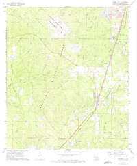
1971 Map of Forest Hill
USGS Topo · Published 1974About this map
Kisatchie National Forest and the Alexander State Forest dominate this central Louisiana landscape, where timber and military interests converge. The northern portion of the quadrangle is occupied by the US Air Force Gunnery Range (Camp Claiborne), a significant military footprint dating back to the World War II era. To the southeast, the Missouri Pacific Railroad services the corridor through Forest Hill and Longleaf, supporting the local gravel and lumber economies. Rural life is anchored by family and community landmarks such as Amiable Ch, Liberty Hill Ch, and the Moore Cem. Notable recreational features like the Forest Hill Speedway and a Drag Strip near the State Forest boundary indicate a local culture tied to motorsports and outdoor activity during the early 1970s.
Find a feature on this map
45 named features on this map. Tap any name to fly to it.
Don’t see what you’re looking for? This feature index may not catch every label — zoom into the map to look around manually.
Map Details
Editions of this 1971 Forest Hill Map
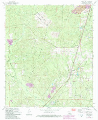
2 editions found
Other maps of this area

1935 · Pawnee
USGS Topo · 1:31,680

1935 · Turkey Creek
USGS Topo · 1:62,500

1935 · Lecompte
USGS Topo · 1:62,500

1942 · Oakdale
USGS Topo · 1:62,500

1949 · Glenmora
USGS Topo · 1:31,680

1949 · Turkey Creek
USGS Topo · 1:62,500

1952 · Lake Charles
USGS Topo · 1:250,000

1953 · Alexandria
USGS Topo · 1:250,000
1954 · Pawnee
USGS Topo · 1:31,680

1954 · Lake Charles
USGS Topo · 1:250,000