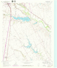
1961 Map of Forreston
USGS Topo · Published 1979About this map
Lake Waxahachie dominates the central landscape of this Ellis County survey, which documents the expansion of Waxahachie and its surrounding rural communities during the late 1950s and early 1960s. The map captures a critical period of infrastructure growth, evidenced by the Filtration Plant and Sewage Disposal facilities near the city limits. A dense network of transportation corridors converges here, including the Missouri Kansas Texas, Chicago Rock Island and Pacific, and Fort Worth and Denver railroads, illustrating the area's role as a transit hub between major North Texas centers.
Find a feature on this map
24 named features on this map. Tap any name to fly to it.
Don’t see what you’re looking for? This feature index may not catch every label — zoom into the map to look around manually.
Map Details
Editions of this 1961 Forreston Map
2 editions found
Other maps of this area

1954 · Dallas
USGS Topo · 1:250,000

1956 · Ennis
USGS Topo · 1:62,500

1958 · Dallas
USGS Topo · 1:250,000

1960 · Boz
USGS Topo · 1:24,000

1961 · Forreston
USGS Topo · 1:24,000
1961 · Midlothian
USGS Topo · 1:24,000
1961 · Waxahachie
USGS Topo · 1:24,000

1962 · Ennis West
USGS Topo · 1:24,000

1962 · Cryer Creek
USGS Topo · 1:24,000
1963 · Palmer
USGS Topo · 1:24,000