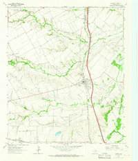
1963 Map of Palmer
USGS Topo · Published 1966About this map
Palmer serves as the central hub of this mid-1960s agricultural and transit corridor in Ellis County, situated along the Southern Pacific railroad. The landscape is defined by the winding paths of Red Oak Creek, Cottonwood Creek, and Brushy Creek, which carve through the terrain and influence the placement of early rural infrastructure. Genealogists will find significant value in the numerous family and community burial grounds documented here, including Douglas Cem, Goslin Cem, and Prude Hyde Cem. In the northern portion of the quadrangle, the community of Trumbull sits near the Cedar Grove Ch, while further south, an Old Railroad Grade hints at earlier transportation alignments that preceded the mid-century highway network. The concentration of local landmarks, such as the High Sch and Community Bldg in Palmer, illustrates the civic core of this Texas farming region.
Find a feature on this map
22 named features on this map. Tap any name to fly to it.
Don’t see what you’re looking for? This feature index may not catch every label — zoom into the map to look around manually.
Map Details
Editions of this 1963 Palmer Map
Other maps of this area

1891 · Dallas
USGS Topo · 1:125,000

1893 · Dallas
USGS Topo · 1:125,000

1954 · Dallas
USGS Topo · 1:250,000

1956 · Ennis
USGS Topo · 1:62,500

1958 · Dallas
USGS Topo · 1:250,000

1959 · Lancaster
USGS Topo · 1:24,000

1959 · Ferris
USGS Topo · 1:24,000

1959 · India
USGS Topo · 1:24,000

1959 · Seagoville
USGS Topo · 1:62,500

1961 · Forreston
USGS Topo · 1:24,000