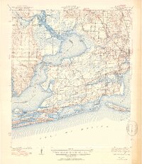
1941 Map of Fort Barrancas
USGS Topo · Published 1941About this map
The Perdido River and Perdido Bay form a sprawling liquid border between Alabama and Florida in this 1941 survey, updated in 1953. The landscape is defined by the military and maritime presence of the Gulf Coast, anchored by the historic Fort Barrancas and the aviation activity at Corry Field. Inland, the settlement pattern shows the growth of suburbs like West Pensacola, Brownsville, and Myrtle Grove, while more rural outposts like Seminole and Lillian dot the western banks across the water.
Find a feature on this map
80 named features on this map. Tap any name to fly to it.
Don’t see what you’re looking for? This feature index may not catch every label — zoom into the map to look around manually.
Map Details
Editions of this 1941 Fort Barrancas Map
3 editions found
Other maps of this area

1920 · Milton
USGS Topo · 1:62,500

1920 · Robertsdale
USGS Topo · 1:62,500

1921 · Bon Secour
USGS Topo · 1:62,500

1921 · Pensacola
USGS Topo · 1:62,500

1921 · Fort Barrancas
USGS Topo · 1:62,500

1921 · Muscogee
USGS Topo · 1:62,500

1941 · Fort Barrancas
USGS Topo · 1:62,500

1941 · Muscogee
USGS Topo · 1:62,500

1941 · Robertsdale
USGS Topo · 1:62,500

1941 · Pensacola
USGS Topo · 1:62,500