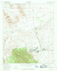
1958 Map of Fort Huachuca
USGS Topo · Published 1969About this map
Fort Huachuca anchors this High Desert landscape, serving as a significant military installation surrounded by the foothills of the Mustang Mts and Coronado National Forest. In the late 1950s, the burgeoning community of Sierra Vista appears adjacent to the post, supported by local institutions like Carmichael School and the Drive-In Theater. The surrounding terrain is a network of canyons and family-named cattle operations, including Babocomari Ranch and Pyeatt Ranch, which reflect the region's ranching heritage. Transport and infrastructure are defined by the Southern Pacific railroad line and various gates such as North Gate and East Gate that control access to the military reservation. Scattered throughout the hills are indicators of the area's extraction history, such as the Manila Mine and various gravel pits, alongside aviation history at Libby Field.
Find a feature on this map
79 named features on this map. Tap any name to fly to it.
Don’t see what you’re looking for? This feature index may not catch every label — zoom into the map to look around manually.
Map Details
Editions of this 1958 Fort Huachuca Map
3 editions found
Other maps of this area

1904 · Patagonia
USGS Topo · 1:125,000

1905 · Patagonia
USGS Topo · 1:125,000

1905 · Nogales
USGS Topo · 1:125,000

1914 · Hereford
USGS Topo · 1:125,000

1915 · Benson
USGS Topo · 1:125,000

1922 · Sunnyside
USGS Topo · 1:62,500

1922 · St. David
USGS Topo · 1:62,500

1926 · Whetstone
USGS Topo · 1:62,500

1932 · Stark
USGS Topo · 1:62,500

1932 · Fairbank
USGS Topo · 1:62,500