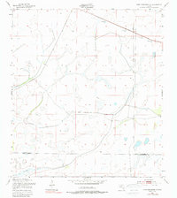
1953 Map of Fort Kissimmee NE
USGS Topo · Published 1988About this map
The boundary between Osceola County and Okeechobee County cuts through this rural landscape as it appeared in the early 1950s. The area is dominated by the complex drainage patterns of Pine Island Slough, reflecting the wet prairie and marshland characteristic of this part of Central Florida. Transport through this difficult terrain is marked by the Peavine Trail and a persistent Old Railroad Grade, indicating former industrial or timber activity that left a physical imprint on the land. Small-scale resource extraction is also visible at various Sand Pit locations along the northern edge of the sheet. The absence of significant residential development at this time highlights the area's history as a remote frontier focused on cattle ranching and natural resource management.
Find a feature on this map
5 named features on this map. Tap any name to fly to it.
Don’t see what you’re looking for? This feature index may not catch every label — zoom into the map to look around manually.
Map Details
Editions of this 1953 Fort Kissimmee NE Map
3 editions found
Other maps of this area

1952 · Fort Kissimmee
USGS Topo · 1:24,000

1952 · Fort Kissimmee NW
USGS Topo · 1:24,000

1953 · Fort Kissimmee NE
USGS Topo · 1:24,000

1953 · Fort Drum SW
USGS Topo · 1:24,000

1953 · Lake Marian SE
USGS Topo · 1:24,000

1953 · Fort Drum NW
USGS Topo · 1:24,000

1953 · Kenansville SW
USGS Topo · 1:24,000

1953 · Lake Marian SW
USGS Topo · 1:24,000

1953 · Fort Kissimmee SE
USGS Topo · 1:24,000

1956 · Fort Pierce
USGS Topo · 1:250,000