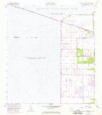
1963 Map of Fort Lauderdale 2 SE
USGS Topo · Published 1971About this map
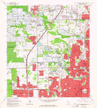
The northern reaches of Broward County and the southern edge of Palm Beach County converge here, dominated by the massive water management infrastructure of the Everglades. The Loxahatchee National Wildlife Refuge and Conservation Area No 1 occupy much of the terrain, defined by an intricate system of embankments such as Levee No 39 and Levee No 40. These features reflect the mid-century engineering efforts to control the flow of water across the landscape, while the Hillsboro Canal cuts a straight path through the wetland. In the eastern portions of the map, residential and recreational growth begins to emerge from the marsh, evidenced by a Golf Course and the established routes of Holmberg Road and Wiles Road. The transition from periodically impounded wetlands to suburban planning is clearly visible in the surveyed grid sections.
Find a feature on this map
13 named features on this map. Tap any name to fly to it.
Don’t see what you’re looking for? This feature index may not catch every label — zoom into the map to look around manually.
Map Details
Editions of this 1963 Fort Lauderdale 2 SE Map
5 editions found

Other maps of this area

1945 · Fort Lauderdale North
USGS Topo · 1:24,000

1946 · West Dixie Bend
USGS Topo · 1:24,000

1947 · Delmar Farms
USGS Topo · 1:24,000

1949 · Fort Lauderdale North
USGS Topo · 1:24,000

1949 · West Dixie Bend
USGS Topo · 1:24,000

1949 · Delmar Farms
USGS Topo · 1:24,000

1956 · West Palm Beach
USGS Topo · 1:250,000

1957 · West Palm Beach
USGS Topo · 1:250,000

1958 · West Palm Beach
USGS Topo · 1:250,000
1962 · Fort Lauderdale North
USGS Topo · 1:24,000