1962 Map of Fort Lauderdale North
USGS Topo · Published 1970About this map
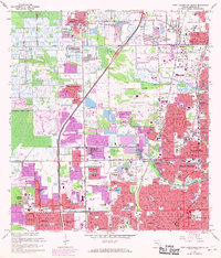
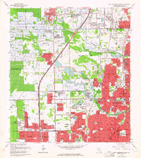
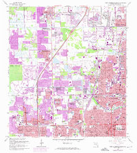
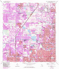
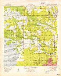
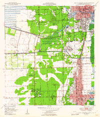
Fort Lauderdale and its northern suburbs are captured here during a period of massive residential expansion in the late 1960s. The map illustrates the burgeoning grid of neighborhoods like Margate, Lauderhill, and Plantation, showing the conversion of citrus groves and wetlands into a dense network of suburban estates. Transport corridors like Floridas Turnpike and the Seaboard Coast Line define the north-south axis of growth, while the New River and its branches, including the North Fork Middle River, reveal the original hydrological character of the landscape. Local landmarks of the era include Tamarac Country Club and several large memorial sites such as Queen of Heaven Cemetery and Lauderdale Mem Gardens (Cemetery). The presence of numerous schools like Dillard High Sch and Ely High Sch reflects the mid-century population boom that transformed this part of Broward County.
Find a feature on this map
86 named features on this map. Tap any name to fly to it.
Don’t see what you’re looking for? This feature index may not catch every label — zoom into the map to look around manually.
Map Details
Editions of this 1962 Fort Lauderdale North Map
4 editions found
Other maps of this area

1945 · Fort Lauderdale North
USGS Topo · 1:24,000

1946 · West Dixie Bend
USGS Topo · 1:24,000
1946 · Boca Raton
USGS Topo · 1:24,000
1949 · Fort Lauderdale North
USGS Topo · 1:24,000
1949 · West Dixie Bend
USGS Topo · 1:24,000
1949 · Port Everglades
USGS Topo · 1:24,000
1949 · Fort Lauderdale South
USGS Topo · 1:24,000
1949 · Pompano Beach
USGS Topo · 1:24,000
1950 · Boca Raton
USGS Topo · 1:24,000

1956 · West Palm Beach
USGS Topo · 1:250,000