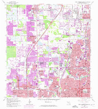
1962 Map of Fort Lauderdale North
USGS Topo · Published 1974About this map
Margate and Oakland Park stand as established hubs in this 1962 survey of Broward County, which captures the region's rapid mid-century expansion. The landscape is defined by an intricate network of waterways, including the Cypress Creek and the branching forks of the Middle River. Rapid residential growth is evident in the sprawling developments of Sabal Palms Estates, Brentwood Estates, and Plantation Gardens. Purple photorevision tints reveal the intense pace of urbanization between 1969 and 1973, particularly around Lauderhill and Sunrise Golf Village. Major infrastructure like the Seaboard Coast Line and Florida's Turnpike serve the growing population, while localized features like Queen of Heaven Cemetery and numerous schools like Ely High Sch and Dillard High Sch provide essential genealogical and community context for this era of South Florida history.
Find a feature on this map
89 named features on this map. Tap any name to fly to it.
Don’t see what you’re looking for? This feature index may not catch every label — zoom into the map to look around manually.
Map Details
Editions of this 1962 Fort Lauderdale North Map
4 editions found
Other maps of this area

1945 · Fort Lauderdale North
USGS Topo · 1:24,000

1946 · West Dixie Bend
USGS Topo · 1:24,000

1946 · Boca Raton
USGS Topo · 1:24,000

1949 · Fort Lauderdale North
USGS Topo · 1:24,000

1949 · West Dixie Bend
USGS Topo · 1:24,000

1949 · Port Everglades
USGS Topo · 1:24,000

1949 · Fort Lauderdale South
USGS Topo · 1:24,000

1949 · Pompano Beach
USGS Topo · 1:24,000

1950 · Boca Raton
USGS Topo · 1:24,000

1956 · West Palm Beach
USGS Topo · 1:250,000