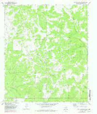
1970 Map of Fort McKavett NW
USGS Topo · Published 1982About this map
The Kamar Oil Field dominates this portion of Schleicher County, revealing an intensive network of extractive industry in the early 1970s. The landscape is characterized by numerous Oil Wells, a Pumping Sta, and scattered Gravel Pits that supported the local infrastructure. Beyond the industrial footprint, the map documents the expansive private holdings of the Texas Hill Country, specifically the Martin Ranch and Webster Ranch. Drainage patterns are defined by the winding course of Rocky Creek in the northeast and Milligan Draw in the southeast, while the topography is broken by the significant depressions of East Poor Hollow and Poor Hollow. This survey captures a specific moment when ranching and energy production coexisted as the primary economic drivers of the region.
Find a feature on this map
16 named features on this map. Tap any name to fly to it.
Don’t see what you’re looking for? This feature index may not catch every label — zoom into the map to look around manually.
Map Details
Editions of this 1970 Fort McKavett NW Map
2 editions found
Other maps of this area

1892 · San Angelo
USGS Topo · 1:125,000

1893 · Fort McKavett
USGS Topo · 1:125,000

1954 · Sonora
USGS Topo · 1:250,000

1954 · San Angelo
USGS Topo · 1:250,000

1958 · Sonora
USGS Topo · 1:250,000

1958 · San Angelo
USGS Topo · 1:250,000

1963 · Adams
USGS Topo · 1:24,000

1963 · Adams SE
USGS Topo · 1:24,000

1965 · San Angelo
USGS Topo · 1:250,000

1970 · Rocking Chair Ranch
USGS Topo · 1:24,000