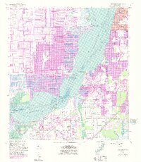
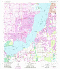
1958 Map of Fort Myers SW
USGS Topo · Published 1991About this map
The Caloosahatchee River dominates this coastal landscape, serving as the dividing line between the established growth of Fort Myers and the extensive canal developments of Cape Coral. Originally surveyed in 1958 and updated via photorevision in the late 1980s, the map reveals a transition from traditional agricultural lands and small settlements like Biggar and Truckland to dense residential grids. Numerous flowing wells are scattered across the flats south of the river, indicating the historical reliance on artesian water for the region’s early development. Significant local markers include the Memorial Gardens cemetery and the Iona Sch, the latter noted as abandoned by the time of revision. Along the shoreline, points such as Cattle Dock Point and Harney Point recall the area's maritime and ranching history, while new recreational spaces like Rutenburg County Park and multiple golf courses signify the mid-century shift toward a leisure-based economy.
Find a feature on this map
44 named features on this map. Tap any name to fly to it.
Don’t see what you’re looking for? This feature index may not catch every label — zoom into the map to look around manually.
Map Details
Editions of this 1958 Fort Myers SW Map
6 editions found
Other maps of this area

1956 · West Palm Beach
USGS Topo · 1:250,000

1956 · Tampa
USGS Topo · 1:250,000

1956 · Charlotte Harbor
USGS Topo · 1:250,000

1957 · West Palm Beach
USGS Topo · 1:250,000

1958 · West Palm Beach
USGS Topo · 1:250,000

1958 · Matlacha
USGS Topo · 1:24,000

1958 · Fort Myers NW
USGS Topo · 1:24,000

1958 · Estero
USGS Topo · 1:24,000

1958 · Fort Myers SW
USGS Topo · 1:24,000

1958 · Sanibel
USGS Topo · 1:24,000