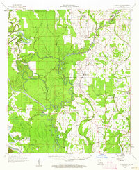
1958 Map of Fort Necessity
USGS Topo · Published 1962About this map
Boeuf River meanders through this portion of Franklin and Caldwell parishes, defining a landscape of bayous, sloughs, and oxbow lakes in the late 1950s. The settlement at Ft Necessity anchors the eastern side of the survey, supported by community institutions like the Ft Necessity School and Boeuf Prairie Church. To the west, the Lafourche Bayou Cutoff and associated spoil banks indicate significant water management and drainage efforts intended to tame the low-lying terrain.
Find a feature on this map
89 named features on this map. Tap any name to fly to it.
Don’t see what you’re looking for? This feature index may not catch every label — zoom into the map to look around manually.
Map Details
Editions of this 1958 Fort Necessity Map
3 editions found

Other maps of this area

1935 · Winnsboro
USGS Topo · 1:62,500

1935 · Alto
USGS Topo · 1:62,500

1935 · Baskinton
USGS Topo · 1:62,500

1939 · Fort Necessity
USGS Topo · 1:62,500

1940 · Monroe
USGS Topo · 1:62,500

1940 · Columbia
USGS Topo · 1:62,500

1941 · Sicily Island
USGS Topo · 1:62,500

1941 · Harrisonburg
USGS Topo · 1:62,500

1953 · Alexandria
USGS Topo · 1:250,000

1953 · Natchez
USGS Topo · 1:250,000