
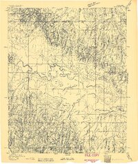
1893 Map of Fort Reno
USGS Topo · Published 1893About this map
The military and indigenous history of central Oklahoma converges at Fort Reno and the nearby Darlington (Cheyenne and Arapahoe Ind Agency). This 1893 survey reveals a landscape of transition, where the North Fork Canadian River meanders through wide bottomlands marked by the Calumet settlement and the smaller enclave of African City. The terrain transitions from the river valley to the dissected uplands of the western portions of Canadian, Blaine, and Kingfisher counties.
Find a feature on this map
11 named features on this map. Tap any name to fly to it.
Don’t see what you’re looking for? This feature index may not catch every label — zoom into the map to look around manually.
Map Details
Editions of this 1893 Fort Reno Map
2 editions found
Other maps of this area

1892 · Kingfisher
USGS Topo · 1:125,000

1893 · Buggy Creek
USGS Topo · 1:62,500

1893 · Minco
USGS Topo · 1:62,500

1893 · Loyal
USGS Topo · 1:62,500

1895 · Kingfisher
USGS Topo · 1:125,000

1904 · Chickasha
USGS Topo · 1:125,000

1941 · Fort Reno
USGS Topo · 1:62,500

1942 · Fort Reno
USGS Topo · 1:62,500

1942 · Geary
USGS Topo · 1:62,500

1949 · Fort Reno
USGS Topo · 1:62,500