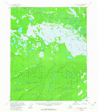
1956 Map of Fort Yukon A-3
USGS Topo · Published 1963About this map
Birch Creek winds through the northern reaches of this interior Alaskan landscape, defining a complex network of oxbow lakes and interconnected wetlands. Photogrammetric methods from the early 1950s captured this transition between the low-lying basin and the higher elevations to the south, where Discovery Creek emerges from the hills. The terrain is marked by significant hydrological features including Egil Island, positioned among the dense river loops that characterize the northern corridor. Surveyed primarily from aerial photographs, the map reflects the unsurveyed and unmarked nature of the land at the time, with land lines predetermined by the Bureau of Land Management rather than ground-based marking. This specific sheet focuses on the wilderness south of the Yukon River, where the meandering drainage patterns of the Birch Creek system dominate the landscape. Remote triangulation points like Vabm 482 provide the few fixed markers in an otherwise fluid environment of shifting streams and marshes.
Find a feature on this map
4 named features on this map. Tap any name to fly to it.
Don’t see what you’re looking for? This feature index may not catch every label — zoom into the map to look around manually.
Map Details
Editions of this 1956 Fort Yukon A-3 Map
2 editions found
Other maps of this area

1951 · Fort Yukon
USGS Topo · 1:250,000

1951 · Circle
USGS Topo · 1:250,000

1952 · Circle D-4
USGS Topo · 1:63,360

1952 · Circle D-3
USGS Topo · 1:63,360

1952 · Circle D-2
USGS Topo · 1:63,360

1955 · Circle
USGS Topo · 1:250,000

1956 · Fort Yukon B-4
USGS Topo · 1:63,360

1956 · Fort Yukon A-2
USGS Topo · 1:63,360

1956 · Fort Yukon A-4
USGS Topo · 1:63,360

1956 · Fort Yukon B-3
USGS Topo · 1:63,360