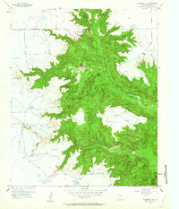
1956 Map of Fortress Cliff
USGS Topo · Published 1963About this map
Palo Duro Canyon State Park dominates this mid-century survey of the Texas Panhandle, revealing the intricate geological carvings of the Red River and its numerous tributaries. The landscape is defined by massive formations such as Fortress Cliff, Lighthouse Peak, and Goodnight Peak, which rise above the floor of Palo Duro Canyon. The map records a distinct intersection of natural wonder and Texas history, specifically noting a Historical Battle Site Marker near the riverbanks. Scattered cattle ranching operations like the Thomas Ranch, Reynolds Ranch, and Krahn Ranch demonstrate the ongoing agricultural utility of the high plains surrounding the canyon rim. Remarkable details include the Mountain Railroad and the distinct plateaus of Elbow Plateau and Swan Plateau, offering a detailed view of the terrain before later modern developments altered the access and infrastructure of this landmark canyon system.
Find a feature on this map
44 named features on this map. Tap any name to fly to it.
Don’t see what you’re looking for? This feature index may not catch every label — zoom into the map to look around manually.
Map Details
Editions of this 1956 Fortress Cliff Map
4 editions found
Other maps of this area

1954 · Amarillo
USGS Topo · 1:250,000

1954 · Plainview
USGS Topo · 1:250,000

1956 · Fortress Cliff
USGS Topo · 1:24,000

1956 · Thomas Ranch
USGS Topo · 1:24,000

1958 · Amarillo
USGS Topo · 1:250,000

1958 · Plainview
USGS Topo · 1:250,000

1960 · Canyon
USGS Topo · 1:62,500

1960 · Fairview
USGS Topo · 1:24,000

1960 · The Palisades
USGS Topo · 1:24,000

1960 · Wayside
USGS Topo · 1:62,500