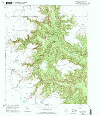
1956 Map of Fortress Cliff
USGS Topo · Published 1978About this map
Palo Duro Canyon State Park dominates this terrain, revealing a complex network of eroded formations and high plateaus in Randall County. The Prairie Dog Town Fork Red River snakes through the canyon floor, flanked by prominent features such as Fortress Cliff and the striking Lighthouse Peak. Significant for local history, the map identifies a Historical Battle Site Marker on the valley floor, marking a specific point of conflict within this landscape. Human presence is scattered across the higher ground and canyon edges, represented by Krahn Ranch and Reynolds Ranch. The interplay of dramatic verticality is shown through named landmarks like Devils Tombstone and Goodnight Peak, while the broad Elbow Plateau and Swan Plateau define the surrounding plains.
Find a feature on this map
31 named features on this map. Tap any name to fly to it.
Don’t see what you’re looking for? This feature index may not catch every label — zoom into the map to look around manually.
Map Details
Editions of this 1956 Fortress Cliff Map
4 editions found
Other maps of this area

1954 · Amarillo
USGS Topo · 1:250,000

1954 · Plainview
USGS Topo · 1:250,000

1956 · Fortress Cliff
USGS Topo · 1:24,000

1956 · Thomas Ranch
USGS Topo · 1:24,000

1958 · Amarillo
USGS Topo · 1:250,000

1958 · Plainview
USGS Topo · 1:250,000

1960 · Canyon
USGS Topo · 1:62,500

1960 · Fairview
USGS Topo · 1:24,000

1960 · The Palisades
USGS Topo · 1:24,000

1960 · Wayside
USGS Topo · 1:62,500