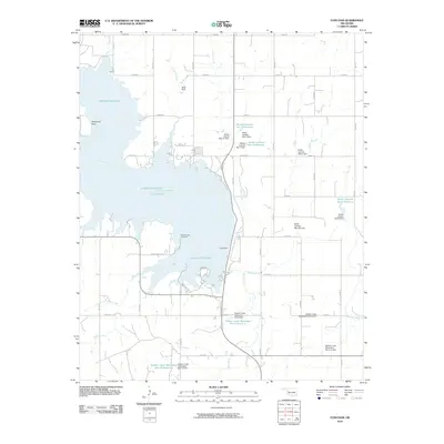
2010 Map of Foss Dam
USGS Topo · Published 2010About this map
Foss Reservoir dominates this landscape in Custer County, representing a major hydraulic engineering project on the Washita River. Completed by the Foss Dam, the reservoir's irregular shoreline creates distinctive features like Cheyenne Point and recreational access via Sandy Beach Rd. The map reveals an extensive water management system beyond the main impoundment, including numerous smaller reservoirs and dams such as the Butler Laterals Site 2 Reservoir and Soldier Creek Watershed Site 8 Reservoir, which serve the agricultural lands of western Oklahoma. For those looking for local history, the Edwardsville Cemetery sits near the eastern shore of the reservoir, a quiet landmark preserved as the surrounding valley was transformed by the rising waters. The terrain is further defined by several tributaries, including Cutberth Creek, Comet Creek, and Little Soldier Creek, which feed into the primary basin.
Find a feature on this map
45 named features on this map. Tap any name to fly to it.
Don’t see what you’re looking for? This feature index may not catch every label — zoom into the map to look around manually.
Map Details
Editions of this 2010 Foss Dam Map
This is the sole edition of this map. No revisions or reprints were ever made.
Other maps of this area

1955 · Clinton
USGS Topo · 1:250,000

1957 · Clinton
USGS Topo · 1:250,000

1957 · Butler
USGS Topo · 1:62,500

1957 · Dill City
USGS Topo · 1:62,500

1960 · Hammon
USGS Topo · 1:62,500

1961 · Elk City
USGS Topo · 1:62,500

1976 · Butler NW
USGS Topo · 1:24,000

1976 · Butler NE
USGS Topo · 1:24,000

1976 · Butler SW
USGS Topo · 1:24,000

1976 · Dill City NE
USGS Topo · 1:24,000