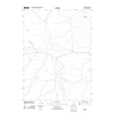
2012 Map of Fossil
USGS Topo · Published 2012About this map
Fossil serves as the central point of this high-plains landscape, where the geography is defined by the complex drainage of Twin Cr and its various branches. To the north, the prominent landmark Fossil Butte and the extensive Fossil Butte National Monument dominate the terrain, protected for their significant paleontological value. The map illustrates a watershed divided by the Colorado River Divide Great Basin, a continental feature that dictates the flow of water across the region. Local infrastructure is represented by a network of county roads like Cnty 300 Rd and Co Rd-331, which connect the scattered points of interest including Hay Hollow and the C H Smith Reservoir. This area reflects a quiet corner of Wyoming where the legacy of the land's ancient past is preserved alongside contemporary ranching and transportation routes.
Find a feature on this map
17 named features on this map. Tap any name to fly to it.
Don’t see what you’re looking for? This feature index may not catch every label — zoom into the map to look around manually.
Map Details
Editions of this 2012 Fossil Map
This is the sole edition of this map. No revisions or reprints were ever made.
Other maps of this area

1954 · Sage
USGS Topo · 1:62,500

1954 · Ogden
USGS Topo · 1:250,000

1954 · Kemmerer
USGS Topo · 1:62,500

1958 · Ogden
USGS Topo · 1:250,000

1960 · Ogden
USGS Topo · 1:250,000

1962 · Bell Butte NE
USGS Topo · 1:24,000

1962 · Elkol
USGS Topo · 1:24,000

1962 · Warfield Creek
USGS Topo · 1:24,000
1979 · Kemmerer
USGS Topo · 1:100,000
1985 · Sublet
USGS Topo · 1:24,000