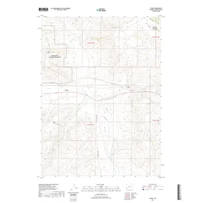
2017 Map of Fossil
USGS Topo · Published 2017About this map
Fossil Butte National Monument occupies the northwestern corner of this 2017 survey, preserving a landscape where the Colorado River Divide Great Basin separates major continental watersheds. The small settlement of Fossil is situated along Twin Creek, a central drainage that branches into the N Fork Twin Cr, E Fork Twin Cr, and S Fork Twin Cr. This complex system of forks and hollows like Hay Hollow defines the local topography, which is marked by prominent elevations such as Fossil Butte and Fossil Ridge. Toward the south, the C H Smith Reservoir serves as a significant water feature amidst a network of rural routes including Twin Creek S and Loma Vista Dr. The map provides a detailed view of the high-desert terrain during the early 21st century.
Find a feature on this map
24 named features on this map. Tap any name to fly to it.
Don’t see what you’re looking for? This feature index may not catch every label — zoom into the map to look around manually.
Map Details
Editions of this 2017 Fossil Map
This is the sole edition of this map. No revisions or reprints were ever made.
Other maps of this area

1954 · Sage
USGS Topo · 1:62,500

1954 · Ogden
USGS Topo · 1:250,000

1954 · Kemmerer
USGS Topo · 1:62,500

1958 · Ogden
USGS Topo · 1:250,000

1960 · Ogden
USGS Topo · 1:250,000

1962 · Bell Butte NE
USGS Topo · 1:24,000

1962 · Elkol
USGS Topo · 1:24,000

1962 · Warfield Creek
USGS Topo · 1:24,000
1979 · Kemmerer
USGS Topo · 1:100,000
1985 · Sublet
USGS Topo · 1:24,000