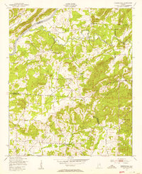
1947 Map of Francis Mill
USGS Topo · Published 1953About this map
The Coosa River flows through this 1940s landscape, serving as the border between St. Clair and Calhoun counties while the Seaboard Air Line railroad follows its course. The terrain is defined by a series of spring-fed waterways, including Cane Creek and Acker Creek, which supported early rural industries like Francis Mill and Martins Mill. This period shows the significant federal footprint in the region, with the Fort McClellan Military Reservation and the Anniston Ordnance Depot occupying substantial acreage on the eastern edge. Local life is centered around rural landmarks like Mt Olive Ch and Union Grove Ch, alongside numerous family springs such as Bailey Springs and Sulphur Springs. The map documents a transition from a mill-and-spring-based economy toward the large-scale military presence that would define the area during and after World War II.
Find a feature on this map
25 named features on this map. Tap any name to fly to it.
Don’t see what you’re looking for? This feature index may not catch every label — zoom into the map to look around manually.
Map Details
Editions of this 1947 Francis Mill Map
4 editions found
Other maps of this area

1889 · Springville
USGS Topo · 1:125,000

1892 · Springville
USGS Topo · 1:125,000

1900 · Anniston
USGS Topo · 1:125,000

1947 · Cox Gap
USGS Topo · 1:24,000

1947 · Eastaboga
USGS Topo · 1:24,000

1947 · Ragland
USGS Topo · 1:62,500

1947 · Ragland
USGS Topo · 1:24,000

1947 · Riverside
USGS Topo · 1:24,000

1947 · Wellington
USGS Topo · 1:24,000

1947 · Francis Mill
USGS Topo · 1:24,000