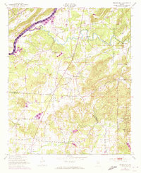
1947 Map of Francis Mill
USGS Topo · Published 1973About this map
Logan Martin Lake and the Coosa River dominate the northwestern corner of this landscape where the borders of Calhoun, St. Clair, and Talladega counties converge. Originally surveyed in the late 1940s with early 1970s updates, the area reveals a rural economy centered on water power and local community hubs like Francis Mill and Martins Mill. The eastern portion of the map is largely defined by the expansive bounds of the Fort McClellan Military Reservation and the Anniston Ordnance Depot Reservation, illustrating the significant military footprint in this part of Alabama during the mid-20th century.
Find a feature on this map
26 named features on this map. Tap any name to fly to it.
Don’t see what you’re looking for? This feature index may not catch every label — zoom into the map to look around manually.
Map Details
Editions of this 1947 Francis Mill Map
4 editions found
Other maps of this area

1889 · Springville
USGS Topo · 1:125,000

1892 · Springville
USGS Topo · 1:125,000

1900 · Anniston
USGS Topo · 1:125,000

1947 · Cox Gap
USGS Topo · 1:24,000

1947 · Eastaboga
USGS Topo · 1:24,000

1947 · Ragland
USGS Topo · 1:62,500

1947 · Ragland
USGS Topo · 1:24,000

1947 · Riverside
USGS Topo · 1:24,000

1947 · Wellington
USGS Topo · 1:24,000

1947 · Francis Mill
USGS Topo · 1:24,000