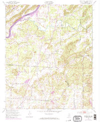
1947 Map of Francis Mill
USGS Topo · Published 1973About this map
Coosa River Logan Martin Lake dominates the northwest corner of this region, reflecting the significant landscape changes brought by mid-century damming and reservoir creation. This 1947 survey, later updated with 1970s photogrammetric revisions, reveals a territory balanced between agricultural roots and large-scale federal footprints. The eastern edge is defined by the Fort Mc Clellan Military Reservation and the Anniston Ordnance Depot Reservation, showing the military's substantial influence on Alabama land use during and after World War II.
Find a feature on this map
26 named features on this map. Tap any name to fly to it.
Don’t see what you’re looking for? This feature index may not catch every label — zoom into the map to look around manually.
Map Details
Editions of this 1947 Francis Mill Map
4 editions found
Other maps of this area

1889 · Springville
USGS Topo · 1:125,000

1892 · Springville
USGS Topo · 1:125,000

1900 · Anniston
USGS Topo · 1:125,000

1947 · Cox Gap
USGS Topo · 1:24,000

1947 · Eastaboga
USGS Topo · 1:24,000

1947 · Ragland
USGS Topo · 1:62,500

1947 · Ragland
USGS Topo · 1:24,000

1947 · Riverside
USGS Topo · 1:24,000

1947 · Wellington
USGS Topo · 1:24,000

1947 · Francis Mill
USGS Topo · 1:24,000