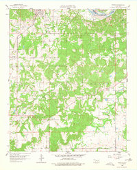
1958 Map of Francis
USGS Topo · Published 1977About this map
The St Louis San Francisco railroad corridor anchors the town of Francis, serving as a central hub for the surrounding oil and agricultural lands. This late 1950s landscape is dotted with several active extraction sites labeled as Oil Field, particularly concentrated north of the Canadian River. The rural community structure is visible through a high density of family and community burial grounds, such as Kilcrease Cem and Denny Cem, alongside small settlements like Colton, Oakman, and Happyland. To the south, the terrain becomes more defined by the drainage systems of Muddy Boggy Creek and its tributaries, West Buck Creek and East Buck Creek. Notable local landmarks like Lovelady Ch and the settlement of Homer further define the social geography of this part of the Chickasaw territory.
Find a feature on this map
24 named features on this map. Tap any name to fly to it.
Don’t see what you’re looking for? This feature index may not catch every label — zoom into the map to look around manually.
Map Details
Editions of this 1958 Francis Map
3 editions found
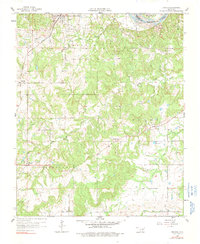
Other maps of this area

1896 · Coalgate
USGS Topo · 1:125,000

1899 · Coalgate
USGS Topo · 1:125,000

1900 · Coalgate
USGS Topo · 1:125,000

1901 · Stonewall
USGS Topo · 1:125,000

1957 · Stonewall
USGS Topo · 1:24,000

1957 · Ardmore
USGS Topo · 1:250,000

1958 · Sasakwa
USGS Topo · 1:24,000

1958 · Lula
USGS Topo · 1:24,000

1958 · Francis
USGS Topo · 1:24,000

1958 · Steedman
USGS Topo · 1:24,000