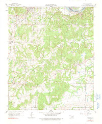
1958 Map of Francis
USGS Topo · Published 1991About this map
The San Francisco railroad cuts a diagonal path through northern Pontotoc County, anchoring the town of Francis and the smaller cluster at Cotton. This 1958 survey captures a landscape defined by petroleum extraction and small rural congregations, notably within the Francis Oil Field and the Miller Oil Field near the Canadian River boundary. The prevalence of family and community burial grounds, such as Oliver Cem, Denny Cem, and Oakman Cem, points to a deeply rooted local history in these hills and creek bottoms.
Find a feature on this map
25 named features on this map. Tap any name to fly to it.
Don’t see what you’re looking for? This feature index may not catch every label — zoom into the map to look around manually.
Map Details
Editions of this 1958 Francis Map
3 editions found
Other maps of this area

1896 · Coalgate
USGS Topo · 1:125,000

1899 · Coalgate
USGS Topo · 1:125,000

1900 · Coalgate
USGS Topo · 1:125,000

1901 · Stonewall
USGS Topo · 1:125,000

1957 · Stonewall
USGS Topo · 1:24,000

1957 · Ardmore
USGS Topo · 1:250,000

1958 · Sasakwa
USGS Topo · 1:24,000

1958 · Lula
USGS Topo · 1:24,000

1958 · Francis
USGS Topo · 1:24,000

1958 · Steedman
USGS Topo · 1:24,000