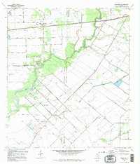
1995 Map of Francitas
USGS Topo · Published 1995About this map
Francitas and the nearby settlement of Deutschburg anchor this coastal Texas landscape along the Jackson Co Matagorda Co line. The area is defined by a dense network of energy infrastructure, including an extensive system of pipelines and numerous oil wells concentrated within the Francitas Field. Water management is central to the local geography, with a complex series of levees lining the winding course of East Carancahua Creek and protecting low-lying acreage. Local life centers on landmarks like the Deutschburg Community Center and the Francitas Cem, while the industrial character of the mid-1990s is visible in the various storage bins, a Compressor Station, and a Radio Facility that dot the coastal prairie near Turtle Creek.
Find a feature on this map
26 named features on this map. Tap any name to fly to it.
Don’t see what you’re looking for? This feature index may not catch every label — zoom into the map to look around manually.
Map Details
Editions of this 1995 Francitas Map
This is the sole edition of this map. No revisions or reprints were ever made.
Other maps of this area

1952 · Francitas NW
USGS Topo · 1:24,000

1952 · Palacios
USGS Topo · 1:24,000

1952 · Olivia
USGS Topo · 1:24,000

1952 · Turtle Bay
USGS Topo · 1:24,000

1952 · Francitas
USGS Topo · 1:24,000

1952 · Blessing
USGS Topo · 1:24,000

1952 · Francitas NE
USGS Topo · 1:24,000

1952 · Midfield
USGS Topo · 1:24,000

1952 · La Ward
USGS Topo · 1:24,000

1953 · Beeville
USGS Topo · 1:250,000