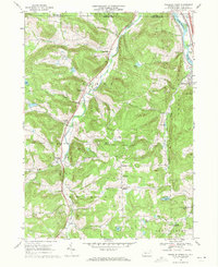
1968 Map of Franklin Forks
USGS Topo · Published 1971About this map
Snake Creek carves a deep valley through the northern Susquehanna County landscape, serving as a primary corridor for small settlements like Brookdale and Stanfordville. This 1960s survey captures a rural landscape where agriculture and industry intersect, evidenced by the numerous quarries and gravel pits dotting the hillsides near Lawsville Center. The eastern edge of the map features the Susquehanna River and the Erie-Lackawanna railroad line, which facilitated the movement of goods through the border region near the New York state line.
Find a feature on this map
39 named features on this map. Tap any name to fly to it.
Don’t see what you’re looking for? This feature index may not catch every label — zoom into the map to look around manually.
Map Details
Editions of this 1968 Franklin Forks Map
Other maps of this area

1904 · Binghamton
USGS Topo · 1:62,500

1905 · Nineveh
USGS Topo · 1:62,500

1932 · Susquehanna
USGS Topo · 1:62,500

1935 · Binghamton West
USGS Topo · 1:24,000

1935 · Susquehanna
USGS Topo · 1:62,500

1937 · Binghamton East
USGS Topo · 1:24,000

1942 · Binghamton West
USGS Topo · 1:31,680

1942 · Binghamton East
USGS Topo · 1:31,680

1943 · Montrose
USGS Topo · 1:62,500

1945 · Montrose
USGS Topo · 1:62,500