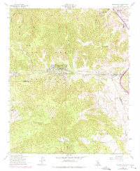
1958 Map of Frazier Mtn
USGS Topo · Published 1975About this map
The San Andreas Rift Zone creates a dramatic geological corridor through this portion of the Los Padres National Forest, where the intersection of three counties—Kern, Ventura, and Los Angeles—meets in a high-elevation landscape. The settlement of Frazier Park serves as a local hub along the Cuddy Canyon, while the northeastern corner is anchored by the site of Fort Tejon State Historical Park near Tejon Pass. This area was a critical mountain passage well before the interstate era, evidenced by the proximity of the Fort Tejon School and family-named holdings like Lebec Oaks Ranch and Mesa Valley Farm. Topographical details reveal a history of resource extraction with the Black Bob Mine and Gold Dust Mine tucked into the canyons. The map also traces a primitive Jeep Trail ascending toward the fire lookout atop Frazier Mountain, overlooking a terrain carved by Hungry Valley and Bradley Canyon.
Find a feature on this map
32 named features on this map. Tap any name to fly to it.
Don’t see what you’re looking for? This feature index may not catch every label — zoom into the map to look around manually.
Map Details
Editions of this 1958 Frazier Mtn Map
4 editions found
Other maps of this area

1903 · Mt. Pinos
USGS Topo · 1:125,000

1903 · Tejon
USGS Topo · 1:125,000

1933 · Gorman
USGS Topo · 1:24,000

1938 · Gorman
USGS Topo · 1:24,000

1942 · Tecuya Creek
USGS Topo · 1:24,000

1942 · Frazier Mountain
USGS Topo · 1:24,000

1943 · Cuddy Valley
USGS Topo · 1:24,000

1943 · Lockwood Valley
USGS Topo · 1:24,000
1944 · Pleito Hills
USGS Topo · 1:31,680
1944 · Frazier Mountain
USGS Topo · 1:31,680