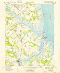
1949 Map of Frederica
USGS Topo · Published 1949About this map
Frederica and the surrounding marshlands of central Kent County are defined by the intricate waterways of the St Jones River and Murderkill River just before they empty into the Delaware Bay. Following the conclusion of World War II, the landscape shows the significant footprint of the Dover Army Air Base in the north, contrasting with the long-established agricultural and maritime character of the region. The map highlights numerous historical gathering places, including the prominent Barratts Chapel and local community centers like John Wesley Ch and the Olive Sch. Coastal life is centered around the small landings and fishing villages such as Bowers, South Bowers, and Kitts Hummock. The transition from river-based transport to modern transit is evident as the Dupont Highway cuts a straight path through traditional districts, connecting the interior settlements of Magnolia and Lebanon to the wider region.
Find a feature on this map
39 named features on this map. Tap any name to fly to it.
Don’t see what you’re looking for? This feature index may not catch every label — zoom into the map to look around manually.
Map Details
Editions of this 1949 Frederica Map
2 editions found
Other maps of this area

1899 · Vineland
USGS Topo · 1:125,000

1899 · Dover
USGS Topo · 1:125,000

1906 · Dover
USGS Topo · 1:125,000

1918 · Cedar Creek
USGS Topo · 1:62,500

1918 · Harrington
USGS Topo · 1:62,500

1919 · Cedar Creek
USGS Topo · 1:62,500

1919 · Vineland
USGS Topo · 1:125,000

1920 · Dover
USGS Topo · 1:125,000

1926 · Wyoming
USGS Topo · 1:48,000

1930 · Wyoming
USGS Topo · 1:62,500