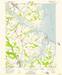
1956 Map of Frederica
USGS Topo · Published 1957About this map
The Murderkill River and St Jones River define this coastal landscape as they wind through tidal marshes toward the Delaware Bay. During the mid-1950s, the region maintained a distinct separation between inland agricultural life and coastal fishing settlements. The Dupont Highway serves as the primary artery, passing through the village of Little Heaven and near the landmark Barratts Chapel. Along the bay, the fishing communities of Bowers and South Bowers sit at the mouth of the Murderkill, while Kitts Hummock marks the northern shoreline. The map reveals the early footprint of Dover Air Force Base in the north, contrasting with the preservation of local history at the Dickinson Mansion. To the south, the town of Frederica is situated at a bend in the river, surrounded by the wetlands of Murderkill Neck.
Find a feature on this map
39 named features on this map. Tap any name to fly to it.
Don’t see what you’re looking for? This feature index may not catch every label — zoom into the map to look around manually.
Map Details
Editions of this 1956 Frederica Map
3 editions found
Other maps of this area

1899 · Vineland
USGS Topo · 1:125,000

1899 · Dover
USGS Topo · 1:125,000

1906 · Dover
USGS Topo · 1:125,000

1918 · Cedar Creek
USGS Topo · 1:62,500

1918 · Harrington
USGS Topo · 1:62,500

1919 · Cedar Creek
USGS Topo · 1:62,500

1919 · Vineland
USGS Topo · 1:125,000

1920 · Dover
USGS Topo · 1:125,000

1926 · Wyoming
USGS Topo · 1:48,000

1930 · Wyoming
USGS Topo · 1:62,500