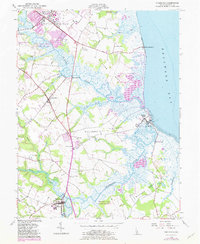
1956 Map of Frederica
USGS Topo · Published 1982About this map
The St Jones River and Murderkill River wind through Kent County's marshy coastal landscape, defining the character of the region as it transitioned into the mid-20th century. This survey documents the significant expansion of the Dover Air Force Base, which dominates the northern portion of the map near Dover. Further south, the town of Frederica and the village of Magnolia serve as inland hubs, connected by the Dupont Highway. Along the Delaware Bay shoreline, small coastal communities such as Bowers Beach and South Bowers sit at the mouth of the Murderkill, while Kitts Hummock marks a lonely landing point further north. Historic sites like the Dickinson Mansion and Barratts Chapel are clearly marked, providing essential points of reference for genealogists and local historians tracing the heritage of this low-lying riverine terrain. The presence of extensive marshes, including the Little Creek Wildlife Area, highlights the natural drainage patterns of Cypress Pond and numerous tidal guts.
Find a feature on this map
38 named features on this map. Tap any name to fly to it.
Don’t see what you’re looking for? This feature index may not catch every label — zoom into the map to look around manually.
Map Details
Editions of this 1956 Frederica Map
3 editions found
Other maps of this area

1899 · Vineland
USGS Topo · 1:125,000

1899 · Dover
USGS Topo · 1:125,000

1906 · Dover
USGS Topo · 1:125,000

1918 · Cedar Creek
USGS Topo · 1:62,500

1918 · Harrington
USGS Topo · 1:62,500

1919 · Cedar Creek
USGS Topo · 1:62,500

1919 · Vineland
USGS Topo · 1:125,000

1920 · Dover
USGS Topo · 1:125,000

1926 · Wyoming
USGS Topo · 1:48,000

1930 · Wyoming
USGS Topo · 1:62,500