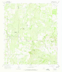
1962 Map of Fredonia
USGS Topo · Published 1975About this map
Fredonia serves as the primary settlement in this section of the Texas Hill Country, where the boundaries of McCulloch, San Saba, and Mason counties converge. The landscape is defined by a network of seasonal watercourses and prominent local elevations, including the distinct Round Mountain and the notably named Hairy Knob. In the early 1960s, this area remained largely rural, centered on ranching and small-scale quarrying as evidenced by various Gravel Pit and Quarries markings. Religious and social life is anchored by the Union Band Ch. near the center of the sheet, while family history is preserved at the Deer Creek Cem and Water Valley Cem. The drainage patterns of Deer Creek, Lost Creek, and the North Fork San Fernando Creek illustrate the watershed of the San Saba River valley, providing a clear record of the region's topography before significant modern development.
Find a feature on this map
23 named features on this map. Tap any name to fly to it.
Don’t see what you’re looking for? This feature index may not catch every label — zoom into the map to look around manually.
Map Details
Editions of this 1962 Fredonia Map
2 editions found
Other maps of this area

1885 · San Saba
USGS Topo · 1:125,000

1887 · Llano
USGS Topo · 1:125,000

1887 · Mason
USGS Topo · 1:125,000

1894 · Brady
USGS Topo · 1:125,000

1894 · Mason
USGS Topo · 1:125,000

1894 · San Saba
USGS Topo · 1:125,000

1894 · Llano
USGS Topo · 1:125,000

1904 · Llano
USGS Topo · 1:125,000

1909 · Llano
USGS Topo · 1:125,000

1918 · Llano
USGS Topo · 1:125,000