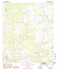
1983 Map of Freemanville
USGS Topo · Published 1983About this map
Poarch and the northern outskirts of Atmore anchor this early 1980s survey of the Alabama-Florida borderlands. The landscape is defined by the winding course of the Perdido River, which separates Baldwin and Escambia counties, and a network of rural settlements connected by the Burlington Northern and Seaboard railroads. Significant community landmarks include Mothershed Cem, Sullivan Cem, and a series of rural congregations such as St Annas Ch and Mt Gilead Ch.
Find a feature on this map
36 named features on this map. Tap any name to fly to it.
Don’t see what you’re looking for? This feature index may not catch every label — zoom into the map to look around manually.
Map Details
Editions of this 1983 Freemanville Map
This is the sole edition of this map. No revisions or reprints were ever made.
Other maps of this area

1941 · Century
USGS Topo · 1:62,500

1942 · Perdido
USGS Topo · 1:62,500

1942 · Dyas
USGS Topo · 1:62,500

1943 · Century
USGS Topo · 1:62,500

1944 · Dyas
USGS Topo · 1:62,500

1944 · Perdido
USGS Topo · 1:62,500

1953 · Andalusia
USGS Topo · 1:250,000

1957 · Andalusia
USGS Topo · 1:250,000

1957 · Pensacola
USGS Topo · 1:250,000

1959 · Pensacola
USGS Topo · 1:250,000