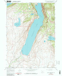
1964 Map of Fremont Lake South
USGS Topo · Published 1986About this map
Fremont Lake dominates this mid-1960s landscape, serving as a glacial centerpiece for the surrounding Bridger National Forest. To the southwest, the town of Pinedale is visible at the edge of the survey, where the Highland Ditch and Pine Creek manage the local water flow. The map illustrates a transitional zone between the high peaks and the valley floor, characterized by steep elevations like Fortification Mountain and the distinct Fremont Ridge that separates the main lake from the smaller Soda Lake and Little Soda Lake. Recreational development is evident through established points such as the Sandy Beach Picnic Area, Half Moon Campground, and a dedicated Winter Sports Area on the eastern slopes. These features, along with the Summit Lake Trail and Skyline Drive, reflect the area's mid-century role as a gateway for mountain exploration and local timber and water management.
Find a feature on this map
35 named features on this map. Tap any name to fly to it.
Don’t see what you’re looking for? This feature index may not catch every label — zoom into the map to look around manually.
Map Details
Editions of this 1964 Fremont Lake South Map
3 editions found

Other maps of this area

1909 · Fremont Peak
USGS Topo · 1:125,000

1955 · Thermopolis
USGS Topo · 1:250,000

1955 · Lander
USGS Topo · 1:250,000

1958 · Lander
USGS Topo · 1:250,000

1958 · Thermopolis
USGS Topo · 1:250,000

1961 · Lander
USGS Topo · 1:250,000

1962 · Thermopolis
USGS Topo · 1:250,000

1964 · Boulder Lake
USGS Topo · 1:24,000

1964 · Mount Airy
USGS Topo · 1:24,000
1964 · Cora
USGS Topo · 1:24,000