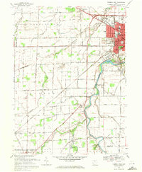
1969 Map of Fremont West
USGS Topo · Published 1971About this map
The Sandusky River carves a winding path through this western section of Fremont, revealing a landscape where mid-century industrial growth met deeply rooted local history. The 1969 survey captures the expansion of the Corp Bdy alongside the established estate of Spiegel Grove State Park. A notable historic landmark, the Mull Covered Bridge, spans the East Branch Wolf Creek in the southern reaches, preserved even as new infrastructure like the Vanguard Voc and Tech Ctr and Progress Field Airport began to define the era's development.
Find a feature on this map
57 named features on this map. Tap any name to fly to it.
Don’t see what you’re looking for? This feature index may not catch every label — zoom into the map to look around manually.
Map Details
Editions of this 1969 Fremont West Map
2 editions found
Other maps of this area

1901 · Fostoria
USGS Topo · 1:62,500

1901 · Fremont
USGS Topo · 1:62,500

1901 · Elmore
USGS Topo · 1:62,500

1903 · Fremont
USGS Topo · 1:62,500

1903 · Fostoria
USGS Topo · 1:62,500

1903 · Elmore
USGS Topo · 1:62,500

1906 · Tiffin
USGS Topo · 1:62,500

1956 · Toledo
USGS Topo · 1:250,000
1957 · Lindsey
USGS Topo · 1:24,000
1957 · Wightmans Grove
USGS Topo · 1:24,000