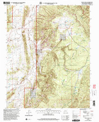
2002 Map of French Mesa
USGS Topo · Published 2003About this map
French Mesa dominates this high-country landscape in Rio Arriba County, where the high plateau meets the Chama River Canyon Wilderness. This 2002 revision by the USDA Forest Service highlights the intricate network of water resources vital for livestock and wildlife in the Santa Fe National Forest, including numerous catchment points such as Guadalupita Tank and Rincon Tank. The terrain transition is sharp, descending from the mesa top into the deep cut of Rincon Colorado.
Find a feature on this map
47 named features on this map. Tap any name to fly to it.
Don’t see what you’re looking for? This feature index may not catch every label — zoom into the map to look around manually.
Map Details
Editions of this 2002 French Mesa Map
This is the sole edition of this map. No revisions or reprints were ever made.
Other maps of this area

1909 · Gallina
USGS Topo · 1:125,000

1940 · Cuba
USGS Topo · 1:62,500

1943 · Cuba
USGS Topo · 1:62,500

1953 · Arroyo Del Agua
USGS Topo · 1:24,000

1953 · Laguna Peak
USGS Topo · 1:24,000

1953 · Navajo Peak
USGS Topo · 1:24,000
1953 · Youngsville
USGS Topo · 1:62,500

1954 · Aztec
USGS Topo · 1:250,000

1955 · Llaves
USGS Topo · 1:62,500

1958 · Aztec
USGS Topo · 1:250,000