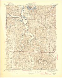
1945 Map of Fristoe
USGS Topo · Published 1945About this map
The Osage River and the meandering Pomme de Terre River define this mid-century Missouri landscape, where the rising waters of the Lake of the Ozarks meet long-established rural settlements. This mid-1940s survey reveals a community anchored by one-room schoolhouses like Evening Shade Sch and Freedom Sch, and remote river crossings such as the Little Mill Creek Ford. The mapping detail captures several upland ridges and hollows, including Gist Ridge and Buzzard Cave Bluff, which speak to the area's complex topography before further modernization. For local historians, the sheet identifies numerous family and community landmarks, from the Seedtick Mine to the Old Baptist Ch and several burial grounds like Cobb Cem and Joplin Cem. The transition from river bottomlands to timbered highlands is documented through the networks of dirt and secondary roads connecting places like Fristoe, Fairfield, and Avery.
Find a feature on this map
95 named features on this map. Tap any name to fly to it.
Don’t see what you’re looking for? This feature index may not catch every label — zoom into the map to look around manually.
Map Details
Editions of this 1945 Fristoe Map
3 editions found

Other maps of this area

1884 · Bolivar
USGS Topo · 1:125,000

1886 · Stockton
USGS Topo · 1:125,000

1887 · Clinton
USGS Topo · 1:125,000

1887 · Warsaw
USGS Topo · 1:125,000

1892 · Bolivar
USGS Topo · 1:125,000

1894 · Warsaw
USGS Topo · 1:125,000

1894 · Clinton
USGS Topo · 1:125,000

1935 · Edwards
USGS Topo · 1:24,000

1935 · Dell
USGS Topo · 1:24,000

1936 · Shawnee Bend
USGS Topo · 1:24,000