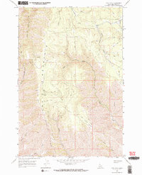
1968 Map of Frye Point
USGS Topo · Published 1971About this map
Craig Mountain and Wapshilla Ridge dominate this late 1960s landscape in Nez Perce County, where the settlement of Zaza stands as a focal point for the surrounding highlands. The topography is defined by a dense network of steep drainages, including Eagle Creek, China Creek, and Wapshilla Creek, which carve deep paths through the high plateaus. These watercourses are supported by natural features like Roberts Spring and the upper reaches of the South Fork Captain John Creek.
Find a feature on this map
20 named features on this map. Tap any name to fly to it.
Don’t see what you’re looking for? This feature index may not catch every label — zoom into the map to look around manually.
Map Details
Editions of this 1968 Frye Point Map
3 editions found
Other maps of this area

1946 · Limekiln Rapids
USGS Topo · 1:62,500

1955 · Pullman
USGS Topo · 1:250,000

1955 · Grangeville
USGS Topo · 1:250,000

1958 · Pullman
USGS Topo · 1:250,000

1959 · Grangeville
USGS Topo · 1:250,000

1963 · Jim Creek Butte
USGS Topo · 1:24,000

1963 · Rattlesnake Ridge
USGS Topo · 1:24,000

1963 · Wapshilla Creek
USGS Topo · 1:24,000

1967 · Hoover Point
USGS Topo · 1:24,000

1968 · Waha
USGS Topo · 1:24,000