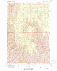
1968 Map of Frye Point
USGS Topo · Published 1971About this map
The Craig Mountains dominate this 1968 landscape in Nez Perce County, where complex drainage systems like Eagle Creek and Captain John Creek carve through the high terrain. The settlement of Zaza serves as the primary human landmark along the western heights, positioned near Roberts Spring. This era shows a network of infrastructure designed for wilderness access, with numerous Jeep Trails threading across Wapshilla Ridge and towards prominent lookouts like Frye Point.
Find a feature on this map
18 named features on this map. Tap any name to fly to it.
Don’t see what you’re looking for? This feature index may not catch every label — zoom into the map to look around manually.
Map Details
Editions of this 1968 Frye Point Map
3 editions found
Other maps of this area

1946 · Limekiln Rapids
USGS Topo · 1:62,500

1955 · Pullman
USGS Topo · 1:250,000

1955 · Grangeville
USGS Topo · 1:250,000

1958 · Pullman
USGS Topo · 1:250,000

1959 · Grangeville
USGS Topo · 1:250,000

1963 · Jim Creek Butte
USGS Topo · 1:24,000

1963 · Rattlesnake Ridge
USGS Topo · 1:24,000

1963 · Wapshilla Creek
USGS Topo · 1:24,000

1967 · Hoover Point
USGS Topo · 1:24,000

1968 · Waha
USGS Topo · 1:24,000