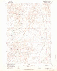
1960 Map of Fuller Reservoir
USGS Topo · Published 1961About this map
Fuller Reservoir and several smaller water catchments punctuate this arid landscape in Fremont County during the early 1960s. The terrain is defined by the drainage networks of Muskrat Creek in the northeast and the winding paths of Cheyenne Creek and Dry Cheyenne Creek to the west. This mapping, revised from 1951 surveys, illustrates a remote ranching and resource environment where water management was central to land use. Isolated Oil Well symbols indicate early energy exploration within these sections, while primitive transit is marked by the courses of Nebo Road and Shoshoni Road. The presence of Allard Reservoir, Brody Reservoir, and Deadman Reservoir suggests a concentrated effort to capture seasonal runoff in a region dominated by deep draws and dry washes.
Find a feature on this map
10 named features on this map. Tap any name to fly to it.
Don’t see what you’re looking for? This feature index may not catch every label — zoom into the map to look around manually.
Map Details
Editions of this 1960 Fuller Reservoir Map
3 editions found
Other maps of this area

1951 · Fuller Reservoir
USGS Topo · 1:24,000

1951 · Indian Butte
USGS Topo · 1:24,000

1951 · Hidden Valley
USGS Topo · 1:24,000

1951 · Shoshoni
USGS Topo · 1:24,000

1952 · Ocla Draw
USGS Topo · 1:24,000

1952 · Double Butte
USGS Topo · 1:24,000

1952 · Haybarn Hill
USGS Topo · 1:24,000

1953 · Campbell Ridge
USGS Topo · 1:24,000

1955 · Thermopolis
USGS Topo · 1:250,000

1955 · Arminto
USGS Topo · 1:250,000