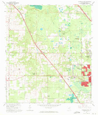
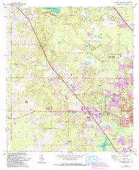
1966 Map of Gainesville West
USGS Topo · Published 1971About this map
The Arredondo Grant area west of Gainesville is captured here in the mid-1960s, a landscape defined by its distinctive karst topography and academic growth. The geological character of the region is centered on the Devils Mill Hopper and Warren Cave, while the presence of the University of Florida Agricultural Experimental Station and University of Florida Experimental Farm highlights the city's expanding educational footprint. Residential development is seen pushing westward through new tracts like Suburban Heights and Beville Heights, bordering the traditional crossroads and small community centers. Local institutions such as Greater Liberty Hill Ch and Westside Sch serve these growing neighborhoods. Industrial and infrastructure markers, including the Seaboard Coast Line railroad and the Stengel Airport in the south, anchor the era's local economy and transport network.
Find a feature on this map
59 named features on this map. Tap any name to fly to it.
Don’t see what you’re looking for? This feature index may not catch every label — zoom into the map to look around manually.
Map Details
Editions of this 1966 Gainesville West Map
6 editions found
Other maps of this area

1890 · Arredondo
USGS Topo · 1:62,500

1892 · Arredondo
USGS Topo · 1:62,500

1894 · Arredondo
USGS Topo · 1:62,500

1954 · Gainesville
USGS Topo · 1:250,000

1958 · Gainesville
USGS Topo · 1:250,000

1959 · Gainesville
USGS Topo · 1:250,000

1962 · High Springs
USGS Topo · 1:24,000
1966 · Micanopy
USGS Topo · 1:24,000

1966 · Gainesville West
USGS Topo · 1:24,000

1966 · Arredondo
USGS Topo · 1:24,000