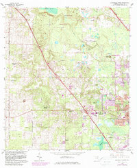
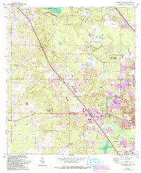
1966 Map of Gainesville West
USGS Topo · Published 1982About this map
San Felasco Hammock State Preserve and the unique sinkhole formation of Devils Mill Hopper State Geological Site anchor the northwestern landscape of this Alachua County survey. The map records the suburban expansion westward from Gainesville, where residential developments like Chantilly Acres, Suburban Heights, and Beville Heights were encroaching upon agricultural and prairie lands. Historical land patterns are still visible through the Arredondo Grant Boundary, which cuts across the terrain, while the University of Florida Agricultural Experimental Station and Experimental Farm highlight the area's academic and scientific character. Notable local landmarks include Warren Cave and the Seaboard Coast Line railroad, alongside several rural spiritual sites such as Mt Nebo Cem and Pine Grove Ch. The low-lying wetlands of Sanchez Prairie and Hogtown Prairie illustrate the natural drainage systems that have historically shaped the region's growth.
Find a feature on this map
50 named features on this map. Tap any name to fly to it.
Don’t see what you’re looking for? This feature index may not catch every label — zoom into the map to look around manually.
Map Details
Editions of this 1966 Gainesville West Map
6 editions found
Other maps of this area

1890 · Arredondo
USGS Topo · 1:62,500

1892 · Arredondo
USGS Topo · 1:62,500

1894 · Arredondo
USGS Topo · 1:62,500

1954 · Gainesville
USGS Topo · 1:250,000

1958 · Gainesville
USGS Topo · 1:250,000

1959 · Gainesville
USGS Topo · 1:250,000

1962 · High Springs
USGS Topo · 1:24,000
1966 · Micanopy
USGS Topo · 1:24,000

1966 · Gainesville West
USGS Topo · 1:24,000

1966 · Arredondo
USGS Topo · 1:24,000